Sampling Stations
|
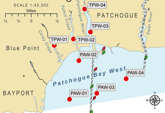
This map shows the 4 tributary stations (TPW) and 4 bay stations (PAW) sampled in this experiment.
|
|
Definitions:
Bay - a body of water that is semi-enclosed Eutrophication - extreme nutrient additions into waterbodies Flushing - exchange or replenishing of water Impervious cover - amount of hard surfaces Permeable surfaces - grasses and soil that can absorb water Runoff - water that is not absorbed Stormwater - water from rain and snow Tributary - a river or stream flowing into a larger waterbody Urbanized watershed - increased paved surfaces that decrease the amount of permeable surfaces Watershed - drainage basin |
Stations were randomly selected to gauge the overall health and suitability of Patchogue's waterways. In total, 8 stations were sampled during each of 6 events from June to September in 2018, 2019, and 2020. Four of those stations are located in the bay and 4 are located in the tributaries leading into the bay: Patchogue River, Corey Creek, Tuthill's Creek. Bays are deeper than tributary sites and can provide habitat for larger species and give more range for their movement. Tributaries are important since they often serve as nursery areas for many aquatic species until they are large enough to compete and survive in more open waters.
It is important to measure both the bay and tributaries to indicate the overall health of the waterways. For example, scientists can determine if there is sufficient flushing of the tributaries by looking for large differences in physical conditions (temperature, salinity, etc.) between the surface conditions of the bay and the tributaries on the same day. Adequate flushing is when the physical conditions are relatively the same each day, indicating that the water from the bay is flowing into the tributaries at a reasonable rate. Inadequate flushing is when conditions are different between the bay and tributary, likely resulting from physical features such as a bulkhead or a narrow inlet to the tributary that obstruct flow. Minimal flushing causes stagnant water to remain in tributaries and can lead to lower dissolved oxygen levels and more particulate matter to accumulate, which can have negative impacts on animals and plant species in the region. Tributary health can also identify sources of pollution into larger waterways. Tributaries collect water from the surrounding area, or watershed. This water is largely from stormwater runoff that accumulates after a storm event when there are not enough permeable surfaces to absorb the water. Urbanized watersheds decrease the amount of permeable surfaces available and increase impervious cover that cannot absorb water. Stormwater drains in the street were created to reduce water accumulation to prevent flooding. However, these drains are not filtered so any pollution that is washed away by stormwater is deposited directly into local waterways. Pollution in tributaries is deposited into the bay or larger waterbodies and can affect species living there. One of the major sources of pollution on Long Island is from fertilizer runoff. Fertilizer contains nutrients, like nitrogen, that stimulate plant growth. This causes eutrophication in waterways that can stimulate algal blooms. Algal blooms are problematic since excessive algal biomass at the surface can shade aquatic plants, cause hypoxic conditions at the end of the bloom, and can even release toxins into the water, often resulting in fish kills and closure of shellfish beds. Tracking tributary health can give insight into any sources of pollution into larger waterbodies as well as identify possible habitat loss for young species that use these areas as nurseries, which directly impacts future populations. |
